
Arouca Geopark

Don't miss
- walk the 10 footpaths of geotourist interest: PR1, PR4, PR5, PR6, PR7, PR8, PR9, PR13, PR14 and PR15
- explore the Freita Mountain with its rare species of flora and fauna, some of which are endangered
- taste DOP-classified Arouquesa beef
- try the local sweets originally from the Arouca Monastery
- see the interesting Romanesque bell tower of Urrô Church
A Geopark is a park with a geological heritage of exceptional importance, recognised as such by the European Network the and UNESCO Global Geoparks Network. Its objective is geoconservation, education for sustainable development and tourism.
Highlights of the Arouca Geopark, which was recognised by UNESCO in 2009, are the Castanheira Nodular Granite (Pedras Parideiras), the Canelas Giant Trilobites and the Vale do Paiva Ichnofossils. But the inventoried heritage includes 41 geosites, i.e. sites of geological interest that stand out for their uniqueness and value from a scientific, didactic and tourist point of view. This true open-air geological museum, covering an area of 328km2, is surrounded by the Freita, Montemuro and Arada Mountains and crossed by several rivers offering excellent conditions for various activities, such as canyoning, canoeing, kayaking and mountaineering (25 routes in 3 areas of the Freita Mountain). And in the River Paiva rapids, you will find some of the best locations in Portugal for rafting and kayak-rafting.
To fully enjoy these landscapes, the Geopark has defined a Network of 14 Footpaths, 13 of which are short distance walks (PR) and one is a long distance walk (GR), all of them properly waymarked. Fourteen geosites are located along ten of these trails.
At the Geological Interpretation Centre of Canelas, located on PR9 (Schist Route), there is a collection of giant trilobite fossils. These marine animals, some 465 million years old, are internationally protected since they are the largest specimens of trilobites in the world.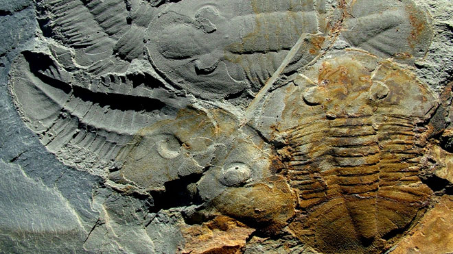
Trilobites ©Arouca Geopark
On PR15 (Journey to Pre-History), close to the village of Castanheira in the Freita Mountain, is another geosite, unique in the country and extremely rare worldwide. This is a granite outcrop with incrusted nodules which, by the action of erosion, pop out spontaneously from the matrix, and so they are known as Pedras Parideiras (rocks delivering stones). Besides the great variety of flora and fauna, you will also find on this mountain the Frecha da Mizarela geosite, where the River Caima drops from a height of about 75 metres. Not far away is the Pedras Boroas do Junqueiro Geosite, two granite blocks that look like corn bread rolls (boroas).
With half of its area classified by the Natura 2000 Network, the whole Geopark is a place of choice for nature tourism, with river beaches and traditional villages that are worth exploring. This is true of the villages of Castanheira and Cabaços on PR15 (Freita Mountain) and Janarde and Meitriz, on PR5, with beaches by the river Paiva, such as Paradinha. But there is also the option of discovering other historic and artistic sites that are well worth a visit. In Arouca, visit the Monastery and the Sacred Art Museum housed there, or the chapel of Misericórdia. And 8km from Arouca, there is a Geosite with the Senhora da Mó Panoramic View, which owes its name to the wide view it offers over the surrounding valleys and hills and where the small chapel of Senhora da Mó is located.
This area also abounds in old tungsten mines, which make as many geosites: from PR8 (the Black Gold Route) or a panoramic spot, you can see the clandestine mine pitheads of the Pena Amarela area; on PR6 are the old Rio de Frades Mines where it is still possible to walk 400m into the Vale da Cerdeira Gallery; and close to the Regoufe village is the Poça da Cadela Mining Complex.


 Explore
 Remember and Share


